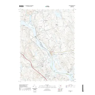
2021 Map of Deep River
USGS Topo · Published 2021About this map
East Haddam and its iconic waterfront anchor this section of the lower Connecticut River valley, where the river narrows between Rich Island and Lord Island. The map details the historic river towns that defined the local economy, from the established village of Chester to the residential centers of Deep River and Hadlyme. Along the eastern heights, the stone ramparts of Gillette Castle overlook the water, situated within the bounds of Gillette Castle State Park.
Find a feature on this map
196 named features on this map. Tap any name to fly to it.
Don’t see what you’re looking for? This feature index may not catch every label — zoom into the map to look around manually.
Map Details
Editions of this 2021 Deep River Map
This is the sole edition of this map. No revisions or reprints were ever made.
Other maps of this area

1892 · Gilead
USGS Topo · 1:62,500

1893 · Guilford
USGS Topo · 1:62,500

1893 · Middletown
USGS Topo · 1:62,500

1893 · Saybrook
USGS Topo · 1:62,500

1906 · Farmington
USGS Topo · 1:125,000

1941 · Lyme
USGS Topo · 1:31,680

1944 · Essex
USGS Topo · 1:31,680

1944 · Deep River
USGS Topo · 1:31,680

1945 · Middle Haddam
USGS Topo · 1:31,680
1945 · Colchester
USGS Topo · 1:31,680