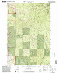
1998 Map of Deer Mountain
USGS Topo · Published 2002About this map
Sleeping Child Hot Springs serves as a primary landmark within this mountain landscape, which is heavily defined by the drainage patterns of the Bitterroot National Forest. The topography is characterized by a series of deep gulches and creek valleys, including Sleeping Child Creek and its tributary Little Sleeping Child Creek, which cut through the high elevations of Deer Mountain and Blacktail Point.
Find a feature on this map
31 named features on this map. Tap any name to fly to it.
Don’t see what you’re looking for? This feature index may not catch every label — zoom into the map to look around manually.
Map Details
Editions of this 1998 Deer Mountain Map
This is the sole edition of this map. No revisions or reprints were ever made.
Other maps of this area

1901 · Hamilton
USGS Topo · 1:125,000

1909 · Sapphire
USGS Topo · 1:125,000

1947 · Butte
USGS Topo · 1:250,000

1955 · Dillon
USGS Topo · 1:250,000

1956 · Elk City
USGS Topo · 1:250,000

1956 · Hamilton
USGS Topo · 1:250,000

1957 · Dillon
USGS Topo · 1:250,000

1958 · Butte
USGS Topo · 1:250,000

1958 · Dillon
USGS Topo · 1:250,000

1959 · Hamilton
USGS Topo · 1:250,000