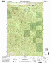
1999 Map of Deer Peak
USGS Topo · Published 2003About this map
Deer Peak Lookout stands as a prominent high point in this remote section of the Lolo National Forest, situated along the border of Mineral and Missoula counties. The map, revised in the late 1990s, documents a landscape defined by steep drainage systems and narrow gulches typical of the Montana interior. Small-scale resource activity is evidenced by a Gravel Pit in the northern reaches, while the presence of the Hebert settlement suggests a locus of local activity near Sawmill Gulch. This survey provides a clear view of the hydrological network supporting the forest, including the West Fork Petty Creek and several smaller tributaries like Slough Creek and Eds Creek. The layout of these watercourses and the naming of features like Ruben Gulch reflect the early logging and surveying history of the region prior to the turn of the millennium.
Find a feature on this map
11 named features on this map. Tap any name to fly to it.
Don’t see what you’re looking for? This feature index may not catch every label — zoom into the map to look around manually.
Map Details
Editions of this 1999 Deer Peak Map
This is the sole edition of this map. No revisions or reprints were ever made.
Other maps of this area

1911 · Lolo
USGS Topo · 1:250,000

1912 · Missoula
USGS Topo · 1:125,000

1913 · Lolo
USGS Topo · 1:250,000

1956 · Wallace
USGS Topo · 1:250,000

1956 · Hamilton
USGS Topo · 1:250,000

1959 · Hamilton
USGS Topo · 1:250,000

1959 · Tarkio
USGS Topo · 1:62,500

1959 · Alberton
USGS Topo · 1:62,500

1960 · Wallace
USGS Topo · 1:250,000

1960 · Hamilton
USGS Topo · 1:250,000