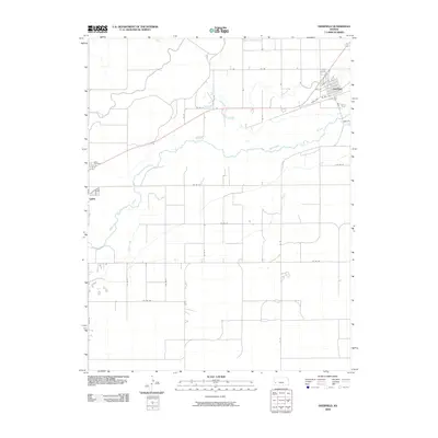
2009 Map of Deerfield
USGS Topo · Published 2009About this map
The Arkansas River meanders across this High Plains landscape, accompanied by an extensive network of irrigation infrastructure essential to the region's agricultural heritage. Large-scale water management projects like the Amazon Ditch and Martin Ditch run roughly parallel to the river, illustrating the complex engineering required to sustain local farming. The settlement of Deerfield sits at the northeastern corner, characterized by a tight grid of streets including Katz Dr and Sixth Ave, while the eastern edge of Lakin is visible to the west. Between these hubs, the terrain is organized by a precise network of county roads such as Co Rd 21 and Co Rd 23, reflecting the systematic Section-Range surveying that defines much of Western Kansas. Near the western margin, the Lakin Cemetery serves as a significant landmark for those researching local family histories.
Find a feature on this map
29 named features on this map. Tap any name to fly to it.
Don’t see what you’re looking for? This feature index may not catch every label — zoom into the map to look around manually.
Map Details
Editions of this 2009 Deerfield Map
This is the sole edition of this map. No revisions or reprints were ever made.
Other maps of this area

1891 · Larned
USGS Topo · 1:125,000

1900 · Lakin
USGS Topo · 1:125,000

1955 · Dodge City
USGS Topo · 1:250,000

1955 · Scott City
USGS Topo · 1:250,000

1958 · Dodge City
USGS Topo · 1:250,000

1958 · Scott City
USGS Topo · 1:250,000

1959 · Dodge City
USGS Topo · 1:250,000
1960 · Deerfield SE
USGS Topo · 1:24,000
1960 · Deerfield SW
USGS Topo · 1:24,000

1960 · Deerfield
USGS Topo · 1:24,000