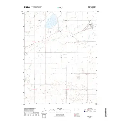
2018 Map of Deerfield
USGS Topo · Published 2018About this map
Deerfield and the eastern edge of Lakin anchor this agricultural landscape in Kearny County, where the management of water defines the terrain. The Arkansas River sweeps across the central portion of the sheet, supplemented by a complex irrigation network including the Amazon Ditch and Martin Ditch. These man-made waterways illustrate the vital role of water engineering in supporting High Plains farming. In the northern reaches, Lake McKinney provides a significant catchment area, surrounded by a grid of rural routes such as Co RD 180 and Co RD V. Local history researchers will find the precise layout of Deerfield's street grid, including Main St and Sixth Ave, while genealogists can locate the Lakin Cem situated just outside the Lakin town limits near the river.
Find a feature on this map
36 named features on this map. Tap any name to fly to it.
Don’t see what you’re looking for? This feature index may not catch every label — zoom into the map to look around manually.
Map Details
Editions of this 2018 Deerfield Map
This is the sole edition of this map. No revisions or reprints were ever made.
Other maps of this area

1891 · Larned
USGS Topo · 1:125,000

1900 · Lakin
USGS Topo · 1:125,000

1955 · Dodge City
USGS Topo · 1:250,000

1955 · Scott City
USGS Topo · 1:250,000

1958 · Dodge City
USGS Topo · 1:250,000

1958 · Scott City
USGS Topo · 1:250,000

1959 · Dodge City
USGS Topo · 1:250,000
1960 · Deerfield SE
USGS Topo · 1:24,000
1960 · Deerfield SW
USGS Topo · 1:24,000

1960 · Deerfield
USGS Topo · 1:24,000