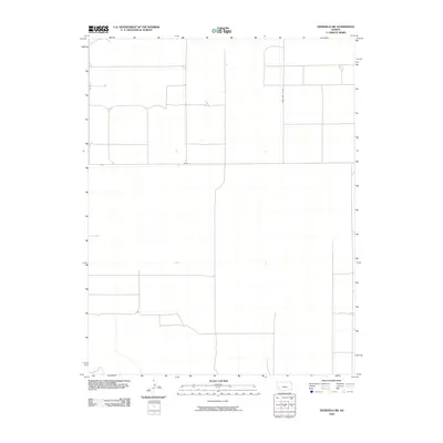
2009 Map of Deerfield SW
USGS Topo · Published 2009About this map
Kearny County farmland is defined by its strict north-south and east-west orientation on this 2009 quadrangle. The agricultural grid is primarily facilitated by the local county road system, which provides the only named infrastructure across this section of the High Plains. Essential rural corridors like Tate Lane Co Rd V and Co Rd Q bisect the landscape, showing the persistent organization of land use in western Kansas. The survey also captures Co Rd 31, highlighting how transportation routes in this era remained tightly bound to section lines. This specific cartography reflects a sparse, open landscape where named features are limited to the arterial roads that connect isolated farmsteads and agricultural plots.
Find a feature on this map
3 named features on this map. Tap any name to fly to it.
Don’t see what you’re looking for? This feature index may not catch every label — zoom into the map to look around manually.
Map Details
Editions of this 2009 Deerfield SW Map
This is the sole edition of this map. No revisions or reprints were ever made.
Other maps of this area

1891 · Larned
USGS Topo · 1:125,000

1900 · Lakin
USGS Topo · 1:125,000

1955 · Dodge City
USGS Topo · 1:250,000

1958 · Dodge City
USGS Topo · 1:250,000

1959 · Dodge City
USGS Topo · 1:250,000

1959 · Ulysses NE
USGS Topo · 1:24,000

1959 · Hickok NW
USGS Topo · 1:24,000

1959 · Hickok NE
USGS Topo · 1:24,000
1960 · Deerfield SE
USGS Topo · 1:24,000
1960 · Deerfield SW
USGS Topo · 1:24,000