
1959 Map of Ulysses NE
USGS Topo · Published 1960About this map
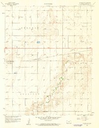
The High Plains of Southwest Kansas are defined here by a systematic grid of energy development and agricultural townships during the late 1950s. The landscape across Kendall, Sherman, and Lincoln is densely punctuated by a network of Gas Wells, illustrating the mid-century intensification of the Hugoton Natural Gas Area. Despite this industrial overlay, the infrastructure of rural community life remains visible, centered on the Pleasant Valley Sch and a Community Hall located near the border of Kearny and Grant counties. The natural topography is relatively subtle, marked primarily by the meandering path of Lakin Draw, which cuts across the central townships and provides the only significant break in the geometric section lines that organize the territory.
Find a feature on this map
9 named features on this map. Tap any name to fly to it.
Don’t see what you’re looking for? This feature index may not catch every label — zoom into the map to look around manually.
Map Details
Editions of this 1959 Ulysses NE Map
This is the sole edition of this map. No revisions or reprints were ever made.
Other maps of this area

1891 · Larned
USGS Topo · 1:125,000

1900 · Lakin
USGS Topo · 1:125,000

1955 · Dodge City
USGS Topo · 1:250,000

1958 · Dodge City
USGS Topo · 1:250,000

1959 · Dodge City
USGS Topo · 1:250,000

1959 · Ulysses NW
USGS Topo · 1:24,000

1959 · Ulysses
USGS Topo · 1:24,000

1959 · Hickok NW
USGS Topo · 1:24,000
1959 · Ulysses SW
USGS Topo · 1:24,000

1959 · Hickok
USGS Topo · 1:24,000