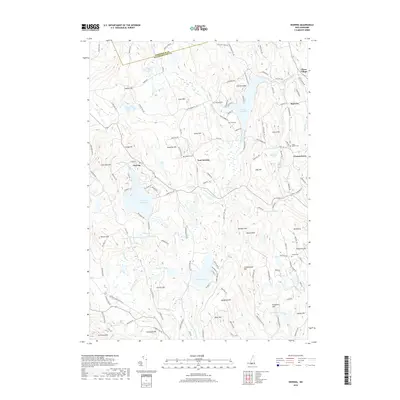
2018 Map of Deering
USGS Topo · Published 2018About this map
Piscataquog River and its southern branch wind through a landscape defined by prominent hills and glacial water bodies in this southern New Hampshire quadrangle. The settlement pattern is characterized by high-elevation landmarks such as Sodom Hill, Gregg Hill, and Crotched Mtn, many of which were likely named for the early families who farmed these slopes. Small historic centers like East Deering, Slab City, and Clinton Grove appear alongside numerous rural burial grounds, including the South Quaker Cem and Bartlett Cem. The map reveals the area's transition into a modern recreational landscape, dominated by the Weare Reservoir and Deering Reservoir. For genealogists, the dense network of named roads like School House Rd and Poor Farm Rd offers clues to the location of former civic institutions and family farmsteads in the hills between the Merrimack and Hillsborough county lines.
Find a feature on this map
137 named features on this map. Tap any name to fly to it.
Don’t see what you’re looking for? This feature index may not catch every label — zoom into the map to look around manually.
Map Details
Editions of this 2018 Deering Map
This is the sole edition of this map. No revisions or reprints were ever made.
Other maps of this area

1900 · Peterboro
USGS Topo · 1:62,500

1906 · Milford
USGS Topo · 1:62,500

1926 · Hillsboro
USGS Topo · 1:62,500

1927 · Concord
USGS Topo · 1:62,500

1929 · Hillsboro
USGS Topo · 1:62,500

1943 · Fitchburg
USGS Topo · 1:125,000

1948 · Boston
USGS Topo · 1:250,000

1949 · Portland
USGS Topo · 1:250,000

1949 · Concord
USGS Topo · 1:62,500
1953 · Peterborough
USGS Topo · 1:62,500