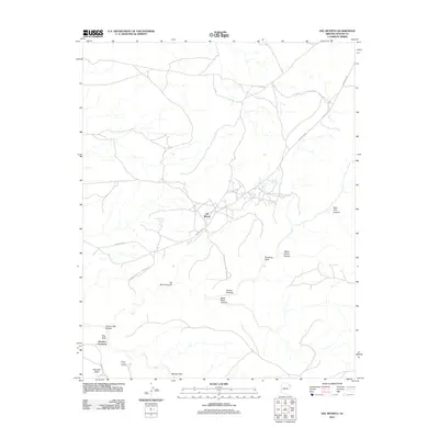
2011 Map of Del Muerto
USGS Topo · Published 2011About this map
Canyon De Chelly Natl Monument dominates this northern Arizona landscape, where the settlement of Del Muerto sits at a critical junction of high-desert roads. This 2011 survey illustrates the complex topography of the Defiance Plateau, marked by deep incisions like Canyon del Muerto and Black Rock Canyon. The map reveals a land of significant cultural and defensive geography, indicated by landmarks such as the Navajo Fortress and the appropriately named Refuge Rock.
Find a feature on this map
21 named features on this map. Tap any name to fly to it.
Don’t see what you’re looking for? This feature index may not catch every label — zoom into the map to look around manually.
Map Details
Editions of this 2011 Del Muerto Map
This is the sole edition of this map. No revisions or reprints were ever made.
Other maps of this area

1892 · Canyon De Chelly
USGS Topo · 1:250,000

1954 · Shiprock
USGS Topo · 1:250,000

1955 · Chinle 4 NE
USGS Topo · 1:24,000

1955 · Chinle 4 SE
USGS Topo · 1:24,000

1955 · Sonsala Butte 2 SW
USGS Topo · 1:24,000

1955 · Sonsala Butte 3 SE
USGS Topo · 1:24,000

1955 · Sonsala Butte 2 SE
USGS Topo · 1:24,000
1955 · Sonsala Butte 3 NE
USGS Topo · 1:24,000
1955 · Sonsala Butte 3 SW
USGS Topo · 1:24,000
1955 · Sonsala Butte 3 NW
USGS Topo · 1:24,000
Featured Places
- Chinle Agency, AZ
- Del Muerto, Chinle Agency
- Junction Overlook, Chinle Agency
- Apache County, AZ
- United States