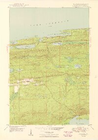
1949 Map of Delaware
USGS Topo · Published 1949About this map
The northern tip of the Keweenaw Peninsula is defined by high ridgelines and the rugged shoreline of Lake Superior in this 1948 field-checked study. The terrain is dominated by the massive presence of Brockway Mountain and Mt Lookout, with Brockway Mountain Drive winding along the crests to provide sweeping views over Agate Harbor and South Bay. This map documents a landscape heavily influenced by geology and early copper mining history, centered around the small settlements of Delaware and Mandan. The water systems here are complex, with the Montreal River and Gratiot River draining the interior uplands toward the Great Lake, while Lac La Belle anchors the southeastern corner. This survey is a snapshot of the region's mid-century character, balancing its mining heritage with its developing reputation as a destination for travelers following the Shore Drive.
Find a feature on this map
37 named features on this map. Tap any name to fly to it.
Don’t see what you’re looking for? This feature index may not catch every label — zoom into the map to look around manually.
Map Details
Editions of this 1949 Delaware Map
4 editions found
Other maps of this area

1927 · Point Isabelle
USGS Topo · 1:31,680

1938 · Bruneau Creek
USGS Topo · 1:31,680

1938 · Delaware
USGS Topo · 1:31,680

1939 · Deer Lake
USGS Topo · 1:31,680

1939 · Delaware
USGS Topo · 1:31,680

1940 · Deer Lake
USGS Topo · 1:31,680

1940 · Central
USGS Topo · 1:31,680

1940 · Lake Medora
USGS Topo · 1:31,680

1946 · Bruneau Creek
USGS Topo · 1:24,000

1946 · Eagle Harbor
USGS Topo · 1:24,000