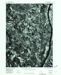
1978 Map of Delmar
USGS Topo · Published 1982About this map
The Hudson River corridor south of Albany defines this orthophotoquad, which captures the suburban and industrial expansion of Albany County in the late 1970s. The aerial imagery provides a direct look at the rail infrastructure and transport hubs near Selkirk and South Albany, revealing the complex track layouts and yards that supported the region's freight economy. Moving inland from the riverbank, the landscape shifts into the residential clusters of Delmar and Bethlehem Center, where post-war housing developments meet older agricultural fields. Natural drainages like Vloman Kill and Onesquethaw Creek cut through the terrain, while the river's eastern shore shows the riverfront character of Castleton-on-Hudson. This map is particularly useful for researchers studying the mid-century evolution of the capital region's transit and settlement patterns.
Find a feature on this map
11 named features on this map. Tap any name to fly to it.
Don’t see what you’re looking for? This feature index may not catch every label — zoom into the map to look around manually.
Map Details
Editions of this 1978 Delmar Map
This is the sole edition of this map. No revisions or reprints were ever made.
Other maps of this area

1893 · Troy
USGS Topo · 1:62,500

1893 · Coxsackie
USGS Topo · 1:62,500

1893 · Albany
USGS Topo · 1:62,500

1894 · Coxsackie
USGS Topo · 1:62,500

1895 · Troy
USGS Topo · 1:62,500

1895 · Albany
USGS Topo · 1:62,500

1898 · Albany
USGS Topo · 1:62,500

1898 · Troy
USGS Topo · 1:62,500

1903 · Kinderhook
USGS Topo · 1:62,500

1925 · Troy
USGS Topo · 1:48,000