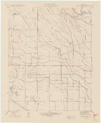
1948 Map of Delta Ranch
USGS Topo · Published 1948About this map
The San Joaquin River and its complex network of sloughs and irrigation works define the agricultural landscape of Merced County in this mid-century survey. Irrigation infrastructure, vital to the region's productivity, is meticulously documented through features like the Colony Main Canal, San Juan Canal, and Agatha Canal, alongside numerous drainage systems such as the West Delta Drain. The map reveals a settlement pattern dominated by large agricultural holdings and company lands rather than traditional townsites, specifically naming the namesake Delta Ranch, San Juan Ranch, and Devon Farm. At the southern edge, the Southern Pacific railroad provides a vital link for moving goods from these inland farms. Local landmarks like the Gaging Sta on the river and the stop at Agatha offer specific points of interest for those tracing the development of Central Valley water management and transit.
Find a feature on this map
43 named features on this map. Tap any name to fly to it.
Don’t see what you’re looking for? This feature index may not catch every label — zoom into the map to look around manually.
Map Details
Editions of this 1948 Delta Ranch Map
This is the sole edition of this map. No revisions or reprints were ever made.
Other maps of this area

1913 · Panoche
USGS Topo · 1:125,000

1916 · Santa Rita Bridge
USGS Topo · 1:24,000

1916 · Delta Ranch
USGS Topo · 1:24,000

1918 · Sandy Mush
USGS Topo · 1:31,680

1918 · Turner Ranch
USGS Topo · 1:31,680

1919 · San Luis Ranch
USGS Topo · 1:31,680

1920 · Santa Rita Bridge
USGS Topo · 1:31,680

1921 · Los Banos
USGS Topo · 1:31,680

1922 · Oxalis
USGS Topo · 1:31,680

1922 · Santa Rita Bridge
USGS Topo · 1:31,680