
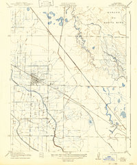
1921 Map of Los Banos
USGS Topo · Published 1921About this map
Los Banos serves as the focal point of this Central Valley survey, showcasing a grid of streets and buildings alongside the Southern Pacific railroad line. The landscape is defined by an intricate network of irrigation and water management, most notably the San Joaquin and Kings River Canal, which cuts through the agricultural allotments of Merced County. To the northeast, the terrain shifts into the marshes and winding watercourses of the Sanjon De Santa Rita and Mud Slough.
Find a feature on this map
12 named features on this map. Tap any name to fly to it.
Don’t see what you’re looking for? This feature index may not catch every label — zoom into the map to look around manually.
Map Details
Editions of this 1921 Los Banos Map
2 editions found
Other maps of this area

1913 · Panoche
USGS Topo · 1:125,000

1916 · Delta Ranch
USGS Topo · 1:24,000

1918 · Turner Ranch
USGS Topo · 1:31,680

1919 · San Luis Ranch
USGS Topo · 1:31,680

1919 · Ingomar
USGS Topo · 1:31,680

1920 · Carrisalito Spring
USGS Topo · 1:31,680

1921 · Volta
USGS Topo · 1:31,680

1922 · Charleston School
USGS Topo · 1:31,680

1922 · Dos Palos
USGS Topo · 1:31,680

1922 · Ortigalita
USGS Topo · 1:31,680