
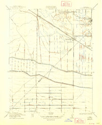
1922 Map of Dos Palos
USGS Topo · Published 1922About this map
Agricultural development and water management define this Central Valley landscape, surveyed in cooperation between the State of California and federal engineers. The sprawling grid of the Dos Palos area is heavily influenced by the San Joaquin and Kings River Canal, which cuts across the territory to support local ranching and farming. Transportation infrastructure is a central theme, showing the Santa Fe railroad line running parallel to the Old Southern Pacific Grade, while the Swamp Road hints at the once-saturated nature of the terrain before extensive drainage. Remote operations such as an Oil Pumping Station and the settlement of Oro Loma appear in the southern sections, marking the intersection of the energy industry and rural outposts. Further north, the connection between Brito and South Dos Palos illustrates the importance of rail access for early twentieth-century valley communities.
Find a feature on this map
11 named features on this map. Tap any name to fly to it.
Don’t see what you’re looking for? This feature index may not catch every label — zoom into the map to look around manually.
Map Details
Editions of this 1922 Dos Palos Map
2 editions found
Other maps of this area

1913 · Panoche
USGS Topo · 1:125,000

1916 · Santa Rita Bridge
USGS Topo · 1:24,000

1916 · Delta Ranch
USGS Topo · 1:24,000

1920 · Santa Rita Bridge
USGS Topo · 1:31,680

1921 · Los Banos
USGS Topo · 1:31,680

1921 · Laguna Seca Ranch
USGS Topo · 1:31,680

1922 · Oxalis
USGS Topo · 1:31,680

1922 · Santa Rita Bridge
USGS Topo · 1:31,680

1922 · Charleston School
USGS Topo · 1:31,680
1922 · Delta Ranch
USGS Topo · 1:31,680