
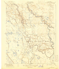
1919 Map of San Luis Ranch
USGS Topo · Published 1919About this map
The San Joaquin River winds through this Merced County landscape, its banks defined by a complex network of seasonal waterways and overflow channels. During this era of early twentieth-century land use, the territory was dominated by large pastoral holdings, including Fremont Ranch, Underwood Ranch, and the eponymous San Luis Ranch. These tracts indicate the transition from open range to more structured ranching operations along the fertile but flood-prone river bottomlands.
Find a feature on this map
10 named features on this map. Tap any name to fly to it.
Don’t see what you’re looking for? This feature index may not catch every label — zoom into the map to look around manually.
Map Details
Editions of this 1919 San Luis Ranch Map
2 editions found
Other maps of this area

1916 · Delta Ranch
USGS Topo · 1:24,000

1918 · Arena
USGS Topo · 1:31,680

1918 · Stevinson
USGS Topo · 1:31,680

1918 · Gustine
USGS Topo · 1:31,680

1918 · Turner Ranch
USGS Topo · 1:31,680

1919 · Ingomar
USGS Topo · 1:31,680

1921 · Volta
USGS Topo · 1:31,680

1921 · Los Banos
USGS Topo · 1:31,680
1922 · Delta Ranch
USGS Topo · 1:31,680
1942 · Irwin
USGS Topo · 1:62,500