
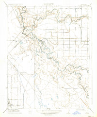
1918 Map of Gustine
USGS Topo · Published 1918About this map
San Joaquin River and Merced River converge in this northern San Joaquin Valley landscape, revealing a complex network of waterways during the late 1910s. The settlement of Gustine is situated in the southwest, while Hills Ferry sits at the northern bend of the river. The topography is dominated by an intricate system of sloughs, including Shag Slough, Mud Slough, and Salt Slough, highlighting the area's natural drainage patterns before modern extensive water management. Human intervention is evidenced by the East Side Irrigation Canal and the Newman Pumping Sta, which supported the growing agricultural needs of the valley. Local life is anchored by landmarks such as the West End School and a small Cem located near the river's path. The map also identifies Fremont Ford, a significant crossing point between the winding river channels and the surrounding Estimba terrain.
Find a feature on this map
17 named features on this map. Tap any name to fly to it.
Don’t see what you’re looking for? This feature index may not catch every label — zoom into the map to look around manually.
Map Details
Editions of this 1918 Gustine Map
2 editions found
Other maps of this area

1916 · Mitchell School
USGS Topo · 1:31,680

1916 · Crows Landing
USGS Topo · 1:31,680

1917 · Turlock
USGS Topo · 1:31,680

1917 · Newman
USGS Topo · 1:31,680

1918 · Stevinson
USGS Topo · 1:31,680

1919 · Orestimba
USGS Topo · 1:62,500

1919 · San Luis Ranch
USGS Topo · 1:31,680

1919 · Ingomar
USGS Topo · 1:31,680

1920 · Pacheco Pass
USGS Topo · 1:62,500

1922 · Howard Ranch
USGS Topo · 1:31,680