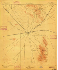
1899 Map of Deming
USGS Topo · Published 1910About this map
Deming serves as the central hub of this late 19th-century landscape, positioned at a critical junction of the Southern Pacific R. R. and the Atchison Topeka and Santa Fe R.R. lines. The convergence of these rail systems in Luna County highlights the area's importance as a transportation gateway between silver mining districts and broader commercial markets. North of the settlement, the Cooks Range rises above the desert floor, harboring the site of Fort Cummings near a vital Spring, illustrating how early military outposts and travel routes were dictated by the scarce water sources of the High Desert.
Find a feature on this map
28 named features on this map. Tap any name to fly to it.
Don’t see what you’re looking for? This feature index may not catch every label — zoom into the map to look around manually.
Map Details
Editions of this 1899 Deming Map
2 editions found
Other maps of this area

1899 · Deming
USGS Topo · 1:125,000

1909 · Silver City
USGS Topo · 1:125,000

1915 · Deming
USGS Topo · 1:125,000

1917 · Hermanas
USGS Topo · 1:62,500

1917 · Camel Mountain
USGS Topo · 1:62,500

1917 · Columbus
USGS Topo · 1:62,500

1918 · Columbus
USGS Topo · 1:62,500

1918 · Hermanas
USGS Topo · 1:62,500

1918 · Victorio
USGS Topo · 1:62,500

1920 · Columbus
USGS Topo · 1:62,500