
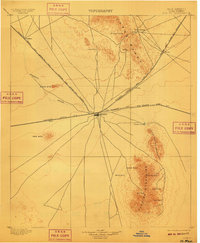
1899 Map of Deming
USGS Topo · Published 1899About this map
Deming emerges as a critical southwestern railroad hub in this late nineteenth-century topographic study, situated at the junction of the Southern Pacific R. R. and the Atchison Topeka and Santa Fe R. R. trunk lines. The settlement pattern follows these steel arteries, with outposts like Tunis, Crawford, and Florida positioned along the rail corridors. To the north, the historic site of Fort Cummings sits near the base of Cooks Range, a remnant of the frontier military presence that predated the railroad boom.
Find a feature on this map
27 named features on this map. Tap any name to fly to it.
Don’t see what you’re looking for? This feature index may not catch every label — zoom into the map to look around manually.
Map Details
Editions of this 1899 Deming Map
2 editions found
Other maps of this area

1909 · Silver City
USGS Topo · 1:125,000

1915 · Deming
USGS Topo · 1:125,000

1917 · Hermanas
USGS Topo · 1:62,500

1917 · Camel Mountain
USGS Topo · 1:62,500

1917 · Columbus
USGS Topo · 1:62,500

1918 · Columbus
USGS Topo · 1:62,500

1918 · Hermanas
USGS Topo · 1:62,500

1918 · Victorio
USGS Topo · 1:62,500

1920 · Columbus
USGS Topo · 1:62,500

1943 · Hermanas
USGS Topo · 1:62,500