1919 Map of Dennisville
USGS Topo · Published 1921About this map
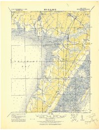
Cape May Courthouse serves as the focal point for this survey of the southern Jersey peninsula, where the landscape is defined by the transition from coastal marshes to interior timberlands. The industrial and maritime character of the early 20th century is evident in the cluster of waterfront sites such as Goshen Landing, West Creek Landing, and Bennie's Landing. These points of transit supported local trade along the Delaware Bay and the intricate network of sounds including Jenkins Sound and Grassy Sound.
Find a feature on this map
68 named features on this map. Tap any name to fly to it.
Don’t see what you’re looking for? This feature index may not catch every label — zoom into the map to look around manually.
Map Details
Editions of this 1919 Dennisville Map
This is the sole edition of this map. No revisions or reprints were ever made.
Other maps of this area

1884 · Sea Isle
USGS Topo · 1:62,500

1888 · Cape May
USGS Topo · 1:62,500

1888 · Dennisville
USGS Topo · 1:62,500

1888 · Sea Isle
USGS Topo · 1:62,500

1890 · Great Egg Harbor
USGS Topo · 1:62,500

1890 · Tuckahoe
USGS Topo · 1:62,500

1890 · Maurice Cove
USGS Topo · 1:62,500

1890 · Bridgeton
USGS Topo · 1:62,500

1891 · Maurice Cove
USGS Topo · 1:62,500

1893 · Cape May
USGS Topo · 1:62,500
Featured Places
- Lower Township, NJ
- Middle Township, NJ
- Upper Township, NJ
- Villas, Lower Township
- Maurice River Township, NJ