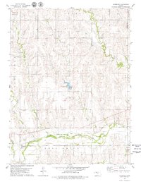
1978 Map of Densmore
USGS Topo · Published 1979About this map
Densmore serves as the primary settlement on this Northwest Kansas landscape, situated just south of the Missouri Pacific railroad line. The topography is defined by the broad valley of the North Fork Solomon River in the south, while the northern sections are divided into townships including Belle Plain, Grant, and Lincoln. This late 1970s survey captures a rural environment where water management and resource extraction are central, evidenced by Big Dutchmen Lake and various industrial markers like a Gravel Pit and a Quarry. Numerous drainage systems including Scull Creek, Cactus Creek, and Timber Creek carve through the terrain, illustrating the complex watershed feeding into the Solomon River. The map also records the boundary line between Norton Co and Phillips Co, providing a clear view of the regional administrative divisions during this era.
Find a feature on this map
19 named features on this map. Tap any name to fly to it.
Don’t see what you’re looking for? This feature index may not catch every label — zoom into the map to look around manually.
Map Details
Editions of this 1978 Densmore Map
This is the sole edition of this map. No revisions or reprints were ever made.
Other maps of this area

1893 · Norton
USGS Topo · 1:125,000

1951 · Norton
USGS Topo · 1:62,500

1955 · Beloit
USGS Topo · 1:250,000

1959 · Beloit
USGS Topo · 1:250,000

1978 · Logan
USGS Topo · 1:24,000
1978 · Calvert
USGS Topo · 1:24,000

1978 · Edmond
USGS Topo · 1:24,000

1978 · Edmond SE
USGS Topo · 1:24,000
1978 · Prairie View
USGS Topo · 1:24,000
1978 · Almena SW
USGS Topo · 1:24,000