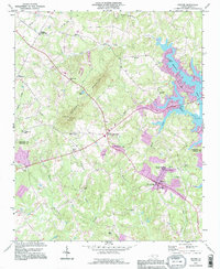
1993 Map of Denver
USGS Topo · Published 1996About this map
Denver and its surrounding rural landscapes in Lincoln Co and Catawba Co are defined by a network of historic crossroads and small country congregations. Significant local landmarks like Drums Crossroads, Olivers Crossroads, and Killian Crossroads mark the intersections of rural life, while churches such as Pisgah Ch, Mt Beulah Ch, and Mt Pleasant Ch served the dispersed farming communities. To the east, the rising waters of Mountain Creek and Reed Creek indicate the shoreline development of the era, complete with a Marina Boat Ramp and Camp Dogwood. Centered on the prominent ridge of Anderson Mountain, the landscape shows a mix of traditional land use and modern utility, from the Quarry near Mundy Creek to the Radio Towers and Lookout Tower standing atop the high ground. Educational and social centers like Rock Springs Sch and Rock Springs Campground reflect the area's deep-rooted community identity during the late twentieth century.
Find a feature on this map
48 named features on this map. Tap any name to fly to it.
Don’t see what you’re looking for? This feature index may not catch every label — zoom into the map to look around manually.
Map Details
Editions of this 1993 Denver Map
This is the sole edition of this map. No revisions or reprints were ever made.
Other maps of this area

1893 · Statesville
USGS Topo · 1:125,000

1895 · Hickory
USGS Topo · 1:125,000

1914 · Gastonia
USGS Topo · 1:48,000

1916 · Gastonia
USGS Topo · 1:62,500

1941 · Charlotte
USGS Topo · 1:125,000

1942 · Charlotte
USGS Topo · 1:125,000

1949 · Hicks Crossroads
USGS Topo · 1:24,000

1953 · Charlotte
USGS Topo · 1:250,000

1954 · Charlotte
USGS Topo · 1:250,000

1960 · Charlotte
USGS Topo · 1:250,000