
1916 Map of Gastonia
USGS Topo · Published 1916About this map
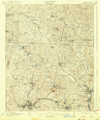
The industrial and spiritual roots of the North Carolina Piedmont are laid bare in this 1914 survey. Textile centers like McAdenville and the Loray Mill in Gastonia anchor the southern landscape, while the presence of the Rehoboth Furnace to the north points to an earlier era of iron production. The South Fork Catawba River winds through the center of the sheet, providing the water power essential to the mills at High Shoals and Hardins Sta.
Find a feature on this map
85 named features on this map. Tap any name to fly to it.
Don’t see what you’re looking for? This feature index may not catch every label — zoom into the map to look around manually.
Map Details
Editions of this 1916 Gastonia Map
2 editions found
Other maps of this area

1893 · Statesville
USGS Topo · 1:125,000

1895 · Hickory
USGS Topo · 1:125,000

1905 · Charlotte
USGS Topo · 1:48,000

1906 · Kings Mountain
USGS Topo · 1:62,500

1907 · Charlotte
USGS Topo · 1:62,500

1908 · Kings Mountain
USGS Topo · 1:62,500

1909 · Lincolnton
USGS Topo · 1:62,500

1911 · Lincolnton
USGS Topo · 1:62,500

1914 · Gastonia
USGS Topo · 1:48,000

1941 · Charlotte
USGS Topo · 1:125,000