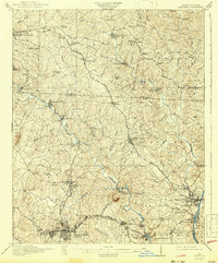
1916 Map of Gastonia
USGS Topo · Published 1943About this map
Industrial and agricultural life in the Piedmont thrives along the South Fork Catawba River and its many tributaries. The landscape is defined by a dense network of textile production and transportation, centered on the growing hub of Gastonia and the prominent Loray Mills complex. This 1914 survey captures the region just as the textile industry was reshaping the local economy, shown through the cluster of mills and mill villages like McAdenville and High Shoals. Beyond the industrial centers, the map documents a deeply rooted rural community, preserving the locations of early iron industry sites like Rehoboth Furnace and spiritual landmarks such as Ebenezer Belmont Abbey. The prominence of Spencer Mtn provides a clear landmark over a terrain crisscrossed by five different railroads, including the Seaboard Air Line and the Southern, which facilitated the movement of goods and people between towns like Lincolnton and Mount Holly.
Find a feature on this map
96 named features on this map. Tap any name to fly to it.
Don’t see what you’re looking for? This feature index may not catch every label — zoom into the map to look around manually.
Map Details
Editions of this 1916 Gastonia Map
2 editions found
Other maps of this area

1893 · Statesville
USGS Topo · 1:125,000

1895 · Hickory
USGS Topo · 1:125,000

1905 · Charlotte
USGS Topo · 1:48,000

1906 · Kings Mountain
USGS Topo · 1:62,500

1907 · Charlotte
USGS Topo · 1:62,500

1908 · Kings Mountain
USGS Topo · 1:62,500

1909 · Lincolnton
USGS Topo · 1:62,500

1911 · Lincolnton
USGS Topo · 1:62,500

1914 · Gastonia
USGS Topo · 1:48,000

1916 · Gastonia
USGS Topo · 1:62,500