
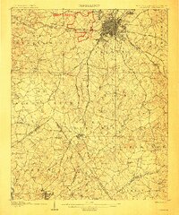
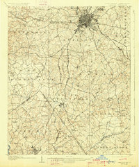
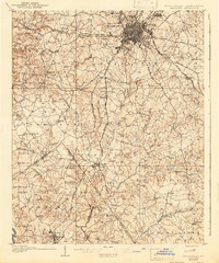
1907 Map of Charlotte
USGS Topo · Published 1907About this map
Charlotte is shown here as a concentrated rail hub at the intersection of the Southern Ry and the Seaboard Air Line Ry. The street grid expands into early suburbs like Dilworth and Piedmont, while landmarks such as Biddle Hall and Elizabeth College anchor the city's academic landscape. Outside the urban core, the terrain is defined by a dense network of country churches and small rural schools that served the surrounding agrarian townships of Steele Creek, Providence, and Crab Orchard.
Find a feature on this map
88 named features on this map. Tap any name to fly to it.
Don’t see what you’re looking for? This feature index may not catch every label — zoom into the map to look around manually.
Map Details
Editions of this 1907 Charlotte Map
4 editions found
Other maps of this area

1905 · Charlotte
USGS Topo · 1:48,000

1914 · Gastonia
USGS Topo · 1:48,000

1916 · Gastonia
USGS Topo · 1:62,500

1941 · Charlotte
USGS Topo · 1:125,000

1941 · Spartanburg
USGS Topo · 1:250,000

1942 · Charlotte
USGS Topo · 1:125,000

1947 · Clover
USGS Topo · 1:62,500

1948 · Paw Creek
USGS Topo · 1:24,000

1948 · Derita
USGS Topo · 1:24,000

1948 · Charlotte East
USGS Topo · 1:24,000