
1948 Map of Paw Creek
USGS Topo · Published 1952About this map
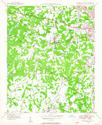
Mountain Island Lake and the Catawba River define the western boundary of this North Carolina landscape, where industrial infrastructure and rural communities intersect in the late 1940s. The shoreline is marked by the Duke Power Village and the Charlotte Waterworks, highlighting the region's developing utility network. Further inland, the rail lines of the Piedmont and Northern and Seaboard Air Line support a string of settlements and industrial sites like Sodyeco, Pinoca, and Chemway. This survey documents a transition in local life, preserving the locations of many country landmarks such as Cooks Memorial Ch, Oakdale Sch, and the Paw Creek (Thrift Sta). The dense network of cemeteries and schools, including Thomasboro High Sch near the Charlotte city limits, provides a clear record of the area's mid-century social fabric.
Find a feature on this map
55 named features on this map. Tap any name to fly to it.
Don’t see what you’re looking for? This feature index may not catch every label — zoom into the map to look around manually.
Map Details
Editions of this 1948 Paw Creek Map
This is the sole edition of this map. No revisions or reprints were ever made.
Other maps of this area

1905 · Charlotte
USGS Topo · 1:48,000

1907 · Charlotte
USGS Topo · 1:62,500

1914 · Gastonia
USGS Topo · 1:48,000

1916 · Gastonia
USGS Topo · 1:62,500

1941 · Charlotte
USGS Topo · 1:125,000

1942 · Charlotte
USGS Topo · 1:125,000

1947 · Clover
USGS Topo · 1:62,500

1948 · Derita
USGS Topo · 1:24,000

1948 · Charlotte East
USGS Topo · 1:24,000
1948 · Charlotte West
USGS Topo · 1:24,000