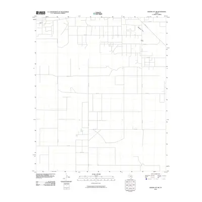
2010 Map of Denver City SW
USGS Topo · Published 2010About this map
Oil and gas infrastructure defines the landscape of this corner of Gaines County, characterized by a dense network of county roads and industrial sites. The topography is largely defined by Wardswell Draw, a natural drainage feature that cuts across the northern portion of the map. Significant energy production hubs are centered around the Russell Oil Field in the northeast and the Brown Oil Field in the northwest, which represent the primary economic drivers of the region during this period. A rigid grid of transportation routes, including Ranch Rd 1757 and numerous county roads such as Co Rd 220 and Co Rd 212, facilitates the movement of equipment and personnel across the Permian Basin terrain. This survey provides a clear view of the intersection between natural landforms and the systematic development of West Texas petroleum resources.
Find a feature on this map
16 named features on this map. Tap any name to fly to it.
Don’t see what you’re looking for? This feature index may not catch every label — zoom into the map to look around manually.
Map Details
Editions of this 2010 Denver City SW Map
This is the sole edition of this map. No revisions or reprints were ever made.
Other maps of this area

1954 · Hobbs
USGS Topo · 1:250,000

1958 · Hobbs
USGS Topo · 1:250,000

1969 · Hobbs East
USGS Topo · 1:24,000

1969 · Humble City NE
USGS Topo · 1:24,000

1969 · Humble City SE
USGS Topo · 1:24,000

1970 · Humble City SE
USGS Topo · 1:24,000

1971 · Paynes Corner
USGS Topo · 1:24,000

1971 · Higginbotham
USGS Topo · 1:24,000
1971 · Denver City
USGS Topo · 1:24,000

1971 · Denver City SW
USGS Topo · 1:24,000