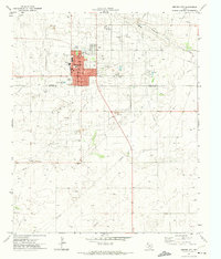
1971 Map of Denver City
USGS Topo · Published 1973About this map
Denver City sits at the heart of this 1971 survey, serving as a concentrated hub of activity within the surrounding Wasson Oil Field. The landscape is a network of industrial progress, characterized by numerous pumping stations, pipelines, and a Power Plant alongside a Gas Plant. While the town is defined by its grid, featuring streets like Broadway and Main, its social character is marked by the Rodeo Ground, the Drive-in Theater, and an Athletic Field near the High Sch. Beyond the residential blocks, the terrain gives way to the open stretches of McKenzie Draw and several gravel excavations. This map illustrates the intersection of a mid-century Texas oil community with its essential infrastructure, from the Airport on the western edge to the Memorial Cem nearby.
Find a feature on this map
27 named features on this map. Tap any name to fly to it.
Don’t see what you’re looking for? This feature index may not catch every label — zoom into the map to look around manually.
Map Details
Editions of this 1971 Denver City Map
This is the sole edition of this map. No revisions or reprints were ever made.
Other maps of this area

1954 · Hobbs
USGS Topo · 1:250,000

1954 · Brownfield
USGS Topo · 1:250,000

1958 · Brownfield
USGS Topo · 1:250,000

1958 · Hobbs
USGS Topo · 1:250,000

1962 · Brownfield
USGS Topo · 1:250,000

1970 · Seagraves SW
USGS Topo · 1:24,000

1970 · Pleasant Hill
USGS Topo · 1:24,000

1970 · Seagraves NW
USGS Topo · 1:24,000

1971 · Higginbotham
USGS Topo · 1:24,000
1971 · Ink Basin
USGS Topo · 1:24,000