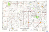
1962 Map of Brownfield
USGS Topo · Published 1962About this map
Levelland and Slaughter Oil and Gas Field dominates the central landscape of this 1962 survey, illustrating the intensive energy development across the High Plains of Texas and New Mexico. Numerous smaller production areas, such as the Bledsoe Oil and Gas Field and Wasson Oil and Gas Field, are densely packed with windmills and tanks, signifying a landscape fully utilized for its mineral resources. The transportation network is defined by the Atchison Topeka and Santa Fe railroad, which links agricultural hubs like Littlefield and Levelland to the broader regional economy. Natural features offer a stark contrast to the industrial grid, including the shifting dunes of the Mescalero Sands and the protected habitats within the Muleshoe National Wildlife Refuge. Regional drainage is marked by intermittent features such as Sulphur Draw and Yellow House Draw, which meander through the Llano Estacado toward the eastern caprock.
Find a feature on this map
85 named features on this map. Tap any name to fly to it.
Don’t see what you’re looking for? This feature index may not catch every label — zoom into the map to look around manually.
Map Details
Editions of this 1962 Brownfield Map
This is the sole edition of this map. No revisions or reprints were ever made.
Historical Maps of Lubbock Through Time
4 maps found