1954 Map of Lubbock
USGS Topo · Published 1958About this map
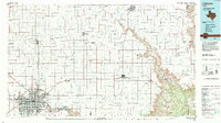
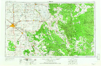
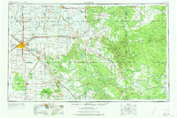
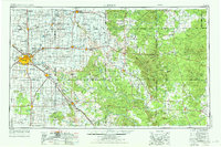
Lubbock stands as the central hub of this 1954 landscape, where the flat plains of the Llano Estacado meet the eroding breaks of the Caprock Escarpment. The map reveals a region defined by its hydrography and early industrial footprint, featuring the extensive headwaters of the Double Mountain Fork Brazos River and Yellow House Draw. The era's economic drivers are clearly visible through the presence of the Lubbock Oil Field, Lutrick Oil Field, and the Garza Oil Field, indicating the importance of petroleum alongside the established agricultural settlements of Abernathy, Floydada, and Tahoka. Moving east, the terrain becomes more varied as the Salt Fork Brazos River carves through the land near landmarks like Soldier Mound and Courthouse Mountain. This survey documents a critical period of infrastructure, showing the Santa Fe and Burlington rail lines connecting isolated rural outposts like Roaring Springs and Old Glory to the growing urban center.
Find a feature on this map
102 named features on this map. Tap any name to fly to it.
Don’t see what you’re looking for? This feature index may not catch every label — zoom into the map to look around manually.
Map Details
Editions of this 1954 Lubbock Map
4 editions found
Historical Maps of Lubbock Through Time
3 maps found