1954 Map of Lubbock
USGS Topo · Published 1966About this map
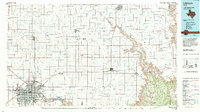
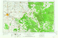
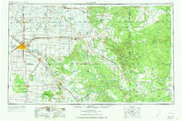
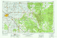
The High Plains and the rolling Caprock escarpment dominate this mid-century survey, centered on the growing hub of Lubbock. The map illustrates the sharp transition between the flat Llano Estacado to the west, marked by numerous small lakes like Double Lakes and Tahoka Lake, and the deeply eroded canyonlands to the east. Transportation corridors of the Panhandle and Santa Fe and the Fort Worth and Denver railroads define the movement of goods and people across the region. Notable landmarks such as Courthouse Mountain and Soldier Mound rise from the breaks of the Brazos River, while the newly formed White River Res signifies the era's focus on water management. Rural life is anchored by small settlements and community centers like Becton Church, McAdoo, and Slaton, reflecting the agricultural and ranching foundations of the South Plains and Rolling Plains before modern interstate expansion.
Find a feature on this map
91 named features on this map. Tap any name to fly to it.
Don’t see what you’re looking for? This feature index may not catch every label — zoom into the map to look around manually.
Map Details
Editions of this 1954 Lubbock Map
4 editions found

Historical Maps of Lubbock Through Time
3 maps found