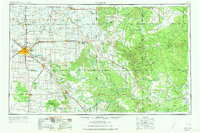
1954 Map of Lubbock
USGS Topo · Published 1973About this map
The High Plains and the rugged Caprock Escarpment define the geography of the South Plains in the mid-1950s. Lubbock serves as the regional hub, where the Panhandle and Santa Fe RR and several major highways converge. The map illustrates the transition from the flat, agricultural Llano Estacado in the west, marked by numerous small intermittent lakes like Tahoka Lake and Double Lakes, to the deeply eroded canyons of the east. These breaks are carved by the headwaters of the Brazos River and the North Fork Wichita River.
Find a feature on this map
123 named features on this map. Tap any name to fly to it.
Don’t see what you’re looking for? This feature index may not catch every label — zoom into the map to look around manually.
Map Details
Editions of this 1954 Lubbock Map
4 editions found

Other maps of this area

1891 · Anson
USGS Topo · 1:125,000

1893 · Roby
USGS Topo · 1:125,000

1893 · Anson
USGS Topo · 1:125,000

1925 · Aspermont 4-a
USGS Topo · 1:48,000

1925 · Haskell 3-b
USGS Topo · 1:48,000

1926 · Snyder 1-a
USGS Topo · 1:48,000

1926 · Roby 2-b
USGS Topo · 1:48,000

1931 · Rotan
USGS Topo · 1:62,500

1931 · Aspermont
USGS Topo · 1:62,500

1932 · Vivian
USGS Topo · 1:62,500