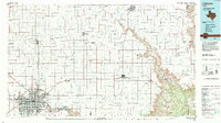
1986 Map of Lubbock
USGS Topo · Published 1994About this map
Lubbock dominates the southwestern corner of this mid-1980s landscape, serving as the primary urban hub for a vast agricultural network on the Llano Estacado. The map reveals the intricate grid of rural roads and section lines that define the region, punctuated by numerous playa lakes and smaller settlements like Shallowater, Idalou, and Lorenzo. To the east, the dramatic erosion of Blanco Canyon and Yellow House Canyon cuts through the High Plains, where the White River and Crawfish Creek have carved deep relief into the otherwise level terrain. This survey captures a transitional period of growth for institutions like Lubbock Christian College and the expansion of the International Airport. Significant local history markers include the Petersburg Cem and early settlements such as Estacado, offering a detailed view of the High Plains community structure before late-twentieth-century consolidation.
Find a feature on this map
58 named features on this map. Tap any name to fly to it.
Don’t see what you’re looking for? This feature index may not catch every label — zoom into the map to look around manually.
Map Details
Editions of this 1986 Lubbock Map
2 editions found
Other maps of this area

1954 · Lubbock
USGS Topo · 1:250,000

1954 · Plainview
USGS Topo · 1:250,000

1954 · Clovis
USGS Topo · 1:250,000

1954 · Brownfield
USGS Topo · 1:250,000

1956 · Shallowater
USGS Topo · 1:24,000

1956 · New Deal
USGS Topo · 1:24,000

1957 · Lubbock East
USGS Topo · 1:24,000

1957 · New Home
USGS Topo · 1:62,500

1957 · Lubbock West
USGS Topo · 1:24,000

1957 · Lubbock
USGS Topo · 1:62,500