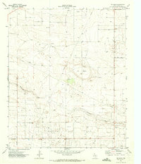
1971 Map of Ink Basin
USGS Topo · Published 1973About this map
The Wasson Oil Field dominates the landscape of this portion of Yoakum County, marked by a dense network of wells and support infrastructure in the early 1970s. The terrain is defined by the broad depression of Ink Basin and the winding course of McKenzie Draw, which cuts across the arid West Texas plains. Several industrial Pipeline corridors traverse the quadrangle, reflecting the region's intensive energy production during this era. Local transportation is facilitated by a grid of named rural routes, including Edwards Road and Allsup Road, which provide access to scattered Gravel Pit operations and the numerous drill sites. This survey captures a specific moment in the expansion of the Permian Basin's oil economy, showing how industrial development integrated with the natural drainage patterns of the High Plains.
Find a feature on this map
9 named features on this map. Tap any name to fly to it.
Don’t see what you’re looking for? This feature index may not catch every label — zoom into the map to look around manually.
Map Details
Editions of this 1971 Ink Basin Map
This is the sole edition of this map. No revisions or reprints were ever made.
Other maps of this area

1954 · Hobbs
USGS Topo · 1:250,000

1954 · Brownfield
USGS Topo · 1:250,000

1958 · Brownfield
USGS Topo · 1:250,000

1958 · Hobbs
USGS Topo · 1:250,000

1962 · Brownfield
USGS Topo · 1:250,000

1969 · Humble City NE
USGS Topo · 1:24,000

1970 · Prairieview NE
USGS Topo · 1:24,000

1970 · Prairieview SE
USGS Topo · 1:24,000

1971 · Plains NW
USGS Topo · 1:24,000

1971 · Higginbotham
USGS Topo · 1:24,000