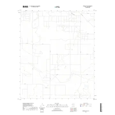
2019 Map of Denver City SW
USGS Topo · Published 2019About this map
Wardswell Draw carves a subtle path through this Gaines County landscape, illustrating the ephemeral drainage patterns characteristic of the Llano Estacado. The terrain is defined by a strictly organized grid of county roads, such as Co Rd 212 and Co Rd 208, which reflect the region's methodical approach to land management and agricultural access. A primary thoroughfare, Ranch Rd 1757, provides the main transit corridor through the northern sections, connecting isolated ranching operations to the wider region. This 2019 survey captures the area in a state of quiet transition, where the natural contours of the West Texas plains meet the precision of modern rural infrastructure.
Find a feature on this map
13 named features on this map. Tap any name to fly to it.
Don’t see what you’re looking for? This feature index may not catch every label — zoom into the map to look around manually.
Map Details
Editions of this 2019 Denver City SW Map
This is the sole edition of this map. No revisions or reprints were ever made.
Other maps of this area

1954 · Hobbs
USGS Topo · 1:250,000

1958 · Hobbs
USGS Topo · 1:250,000

1969 · Hobbs East
USGS Topo · 1:24,000

1969 · Humble City NE
USGS Topo · 1:24,000

1969 · Humble City SE
USGS Topo · 1:24,000

1970 · Humble City SE
USGS Topo · 1:24,000

1971 · Paynes Corner
USGS Topo · 1:24,000

1971 · Higginbotham
USGS Topo · 1:24,000
1971 · Denver City
USGS Topo · 1:24,000

1971 · Denver City SW
USGS Topo · 1:24,000