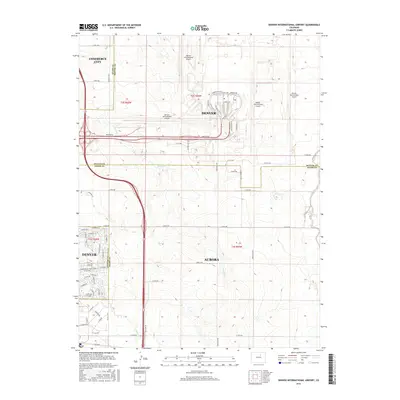
2016 Map of Denver International Airport
USGS Topo · Published 2016About this map
Denver International Airport serves as the central anchor for this 2016 survey, showcasing the complex infrastructure of terminal roads and runways that define the high plains east of Denver. The landscape is a study in transition, where the expanding residential footprints of Aurora and Commerce City meet the vast agricultural and utility corridors of Adams County. Local transit is dominated by the sprawling interchange of Pena Blvd, which cuts across the drainage basins of Second Creek and Third Creek. While the northern sections are dedicated to aviation logistics along Terminal Rd and Loading Dock Rd, the southern reaches of the map retain older rural markers like Gun Club Rd and Smith Rd. This document captures the intersection of mid-century township-and-range boundaries with modern urban development, illustrating how watercourses like Box Elder Creek and First Creek persist even as the surrounding prairie is reorganized for 21st-century travel.
Find a feature on this map
66 named features on this map. Tap any name to fly to it.
Don’t see what you’re looking for? This feature index may not catch every label — zoom into the map to look around manually.
Map Details
Editions of this 2016 Denver International Airport Map
This is the sole edition of this map. No revisions or reprints were ever made.
Other maps of this area

1890 · East Denver
USGS Topo · 1:125,000

1935 · East Denver Nos. 3 and 4
USGS Topo · 1:48,000

1938 · Long Branch
USGS Topo · 1:24,000

1939 · Coal Creek
USGS Topo · 1:24,000

1940 · Brighton
USGS Topo · 1:31,680

1941 · Long Branch
USGS Topo · 1:31,680

1941 · Fitzsimons
USGS Topo · 1:31,680

1942 · Mile High Lakes
USGS Topo · 1:31,680

1942 · Box Elder School
USGS Topo · 1:31,680

1942 · Coal Creek
USGS Topo · 1:31,680