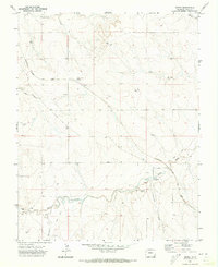
1971 Map of Deora
USGS Topo · Published 1973About this map
The high plains of Baca County are captured here in the early 1970s, defined by the diagonal transit of the Atchison Topeka and Santa Fe railroad across a landscape carved by Two Butte Creek and its tributaries. The small settlement of Deora and nearby Frick anchor the northern portion of the map, while markers of early ranching and prairie commerce, such as the Israel Store (Site) and the Atlanta (Site), offer tangible locations for genealogical research into former homesteads. Educational history is preserved at the Valley View School, situated between the rail line and the dramatic geography of Shell Rock Canyon. The terrain transitions from the high prairie flats to the convoluted drainage systems of Arrasmith Draw and Freezeout Creek, illustrating the environmental factors that shaped early 20th-century settlement patterns in this corner of Colorado.
Find a feature on this map
21 named features on this map. Tap any name to fly to it.
Don’t see what you’re looking for? This feature index may not catch every label — zoom into the map to look around manually.
Map Details
Editions of this 1971 Deora Map
This is the sole edition of this map. No revisions or reprints were ever made.
Other maps of this area

1891 · Higbee
USGS Topo · 1:125,000

1891 · Springfield
USGS Topo · 1:125,000

1892 · Two Butte
USGS Topo · 1:125,000

1892 · Mt Carrizo
USGS Topo · 1:125,000

1893 · Higbee
USGS Topo · 1:125,000

1893 · Two Butte
USGS Topo · 1:125,000

1893 · Springfield
USGS Topo · 1:125,000

1955 · La Junta
USGS Topo · 1:250,000

1958 · La Junta
USGS Topo · 1:250,000

1968 · La Junta
USGS Topo · 1:250,000