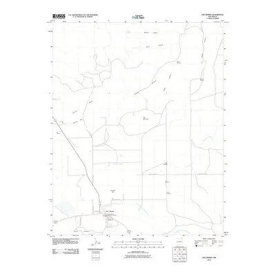
2010 Map of Des Moines
USGS Topo · Published 2010About this map
Des Moines sits at a crossroads of ranching country and volcanic terrain, where the high plains meet the distinctive elevations of the Purvine Hills and Carr Mountain. This northeastern New Mexico landscape is defined by its drainage systems, notably the North Branch Corrumpa Creek and Travesser Creek, which carve through a series of canyons including Briggs Canyon and Fowler Canyon. The map reveals a pattern of rural settlement and resource management, with multiple named windmills such as the Pachta Windmill and Hen Windmill serving as vital water points across the arid expanse.
Find a feature on this map
30 named features on this map. Tap any name to fly to it.
Don’t see what you’re looking for? This feature index may not catch every label — zoom into the map to look around manually.
Map Details
Editions of this 2010 Des Moines Map
This is the sole edition of this map. No revisions or reprints were ever made.
Other maps of this area

1954 · Dalhart
USGS Topo · 1:250,000

1958 · Dalhart
USGS Topo · 1:250,000

1962 · Dalhart
USGS Topo · 1:250,000

1972 · Emery Peak
USGS Topo · 1:24,000

1972 · Little Grande
USGS Topo · 1:24,000
1972 · Cross L Ranch
USGS Topo · 1:24,000

1972 · Cross L Ranch SW
USGS Topo · 1:24,000
1972 · Des Moines
USGS Topo · 1:24,000

1972 · Capulin
USGS Topo · 1:24,000
1972 · Folsom
USGS Topo · 1:24,000