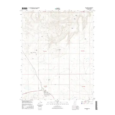
2017 Map of Des Moines
USGS Topo · Published 2017About this map
Des Moines serves as the primary hub for this northeastern New Mexico landscape, situated at the base of prominent volcanic landforms like Dunchee Hill and Twin Mtn. The village layout is clearly defined by several local thoroughfares, including Broadway Ave, Amsdad Rd, and College Ave, reflecting its role as a regional crossroads. Local history is anchored by the Des Moines Cemetery and Catholic Cemetery, providing valuable data points for genealogical research in Union County.
Find a feature on this map
35 named features on this map. Tap any name to fly to it.
Don’t see what you’re looking for? This feature index may not catch every label — zoom into the map to look around manually.
Map Details
Editions of this 2017 Des Moines Map
This is the sole edition of this map. No revisions or reprints were ever made.
Other maps of this area

1954 · Dalhart
USGS Topo · 1:250,000

1958 · Dalhart
USGS Topo · 1:250,000

1962 · Dalhart
USGS Topo · 1:250,000

1972 · Emery Peak
USGS Topo · 1:24,000

1972 · Little Grande
USGS Topo · 1:24,000
1972 · Cross L Ranch
USGS Topo · 1:24,000

1972 · Cross L Ranch SW
USGS Topo · 1:24,000
1972 · Des Moines
USGS Topo · 1:24,000

1972 · Capulin
USGS Topo · 1:24,000
1972 · Folsom
USGS Topo · 1:24,000