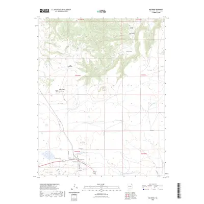
2023 Map of Des Moines
USGS Topo · Published 2023About this map
Des Moines serves as the central hub of this high-plains landscape in Union County, where the village streets like Broadway Ave and College Ave meet the rural ranching roads of northeastern New Mexico. The terrain is defined by a series of volcanic and erosional features, from the massive Sierra Grande in the southwest to the distinctive peaks of Twin Mountain and Carr Mountain. These elevations are cut by numerous drainage systems including Travesser Creek and the North Branch Corrumpa Creek, which flow through various named breaks such as Fowler Canyon and Cow Canyon. Local history is anchored by the presence of the Des Moines Cem and the Des Moines Catholic Cem, while family names are preserved in landmarks like Purvine Hills and Purvine Mesa. The mapping reveals a transition from the structured town grid to the wide-open geography of mesa tops and springs like Mitchel Springs.
Find a feature on this map
39 named features on this map. Tap any name to fly to it.
Don’t see what you’re looking for? This feature index may not catch every label — zoom into the map to look around manually.
Map Details
Editions of this 2023 Des Moines Map
This is the sole edition of this map. No revisions or reprints were ever made.
Other maps of this area

1954 · Dalhart
USGS Topo · 1:250,000

1958 · Dalhart
USGS Topo · 1:250,000

1962 · Dalhart
USGS Topo · 1:250,000

1972 · Emery Peak
USGS Topo · 1:24,000

1972 · Little Grande
USGS Topo · 1:24,000
1972 · Cross L Ranch
USGS Topo · 1:24,000

1972 · Cross L Ranch SW
USGS Topo · 1:24,000
1972 · Des Moines
USGS Topo · 1:24,000

1972 · Capulin
USGS Topo · 1:24,000
1972 · Folsom
USGS Topo · 1:24,000