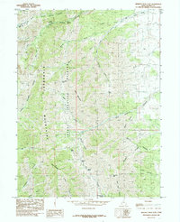
1985 Map of Deseret Peak East
USGS Topo · Published 1985About this map
Wasatch National Forest dominates this high-altitude landscape in the mid-1980s, centered on the jagged ridgelines of the Stansbury Mountains. The terrain is defined by extreme elevation changes, where drainage systems like South Willow Creek have carved deep passages through the Upper Narrows and Lower Narrows. High alpine water sources including North Willow Lake and South Willow Lake sit tucked beneath the peaks, while numerous named springs like Chokecherry Spring and Cold Spring provide critical water points in the drier canyon bottoms. Evidence of human activity is primarily limited to resource extraction and transit, with several areas marked for Mining or Prospects and primitive routes crossing at Box Elder Pass and Hickman Pass. The map reveals a complex network of hollows, such as Slate Rock Hollow and Faraday Hollow, that branch away from the central massif.
Find a feature on this map
38 named features on this map. Tap any name to fly to it.
Don’t see what you’re looking for? This feature index may not catch every label — zoom into the map to look around manually.
Map Details
Editions of this 1985 Deseret Peak East Map
This is the sole edition of this map. No revisions or reprints were ever made.
Other maps of this area

1885 · Tooele Valley
USGS Topo · 1:250,000

1918 · Stockton
USGS Topo · 1:62,500

1953 · Tooele
USGS Topo · 1:250,000

1955 · Timpie
USGS Topo · 1:62,500

1955 · Deseret Peak
USGS Topo · 1:62,500

1955 · Grantsville
USGS Topo · 1:24,000

1955 · Stockton
USGS Topo · 1:62,500

1955 · Tooele
USGS Topo · 1:250,000

1979 · Rush Valley
USGS Topo · 1:100,000
1979 · Tooele
USGS Topo · 1:100,000