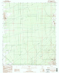
1988 Map of Desert Peak
USGS Topo · Published 1989About this map
Desert Peak stands as the primary landmark in this arid stretch of Pinal County, overlooking a landscape defined by ephemeral drainage systems and resource extraction. The eastern edge of the map is dominated by the Owl Head Buttes and the northern slopes of the Tortolita Mountains, where the rugged topography is marked by several mineral explorations. Evidence of late 20th-century mining activity is visible near these peaks, including a Mine Shaft, an Adit Mine Shaft, and various prospects.
Find a feature on this map
15 named features on this map. Tap any name to fly to it.
Don’t see what you’re looking for? This feature index may not catch every label — zoom into the map to look around manually.
Map Details
Editions of this 1988 Desert Peak Map
2 editions found
Other maps of this area

1934 · Tucson Mountains
USGS Topo · 1:125,000

1934 · Newman Peak
USGS Topo · 1:125,000

1947 · Cortaro
USGS Topo · 1:62,500

1947 · Red Rock
USGS Topo · 1:62,500

1956 · Tucson
USGS Topo · 1:250,000

1957 · Cortaro
USGS Topo · 1:62,500

1958 · Tucson
USGS Topo · 1:250,000

1959 · Tucson
USGS Topo · 1:250,000

1959 · Tortolita Mts
USGS Topo · 1:62,500
1959 · Silver Bell Peak
USGS Topo · 1:62,500