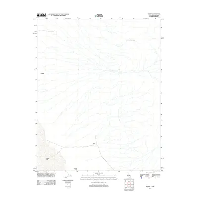
2012 Map of Desert
USGS Topo · Published 2012About this map
Ivanpah Valley dominates this high-desert landscape on the border of California and Nevada, where the drainage patterns of the Lucy Gray Mountains descend into the arid basin. The small settlement of Desert and the site of Calada represent the sparse human footprint in this corner of San Bernardino County during the early 21st century. Infrastructure is defined by the Nipton Desert Rd, which cuts across the dry terrain toward the southern expanse. The presence of Ivanpah Lake at the bottom of the basin reflects the seasonal hydrology of the region, where internal drainage collects in the low-lying salt flats. This survey documents the area's transition from open rangeland to its role in the modern interstate corridor.
Find a feature on this map
7 named features on this map. Tap any name to fly to it.
Don’t see what you’re looking for? This feature index may not catch every label — zoom into the map to look around manually.
Map Details
Editions of this 2012 Desert Map
This is the sole edition of this map. No revisions or reprints were ever made.
Other maps of this area

1910 · Ivanpah
USGS Topo · 1:250,000

1912 · Ivanpah
USGS Topo · 1:250,000

1942 · Ivanpah
USGS Topo · 1:250,000

1947 · Kingman
USGS Topo · 1:250,000

1948 · Kingman
USGS Topo · 1:250,000

1954 · Kingman
USGS Topo · 1:250,000

1955 · Kingman
USGS Topo · 1:250,000

1955 · Roach Lake
USGS Topo · 1:62,500

1956 · Ivanpah
USGS Topo · 1:62,500
1956 · Crescent Peak
USGS Topo · 1:62,500