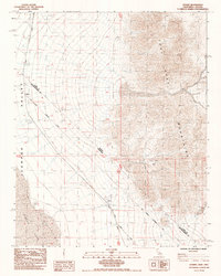
1985 Map of Desert
USGS Topo · Published 1985About this map
Von Schmidt Boundary (1873) cuts across this desert landscape, marking the historic line between Nevada and California. The rugged eastern portion is dominated by the Lucy Gray Mountains, where the Lucy Gray Mine stands as a focal point of industrial activity. To the west, the arid expanse of the Ivanpah Valley and the dry bed of Ivanpah Lake define the terrain. The Union Pacific railroad runs through the valley, serving the small settlement of Calada. This map also preserves precise historical markers such as the 3 1/2 Mile Mon State Mon 126, which anchors the 19th-century survey lines through this high-desert region of Clark and San Bernardino counties.
Find a feature on this map
10 named features on this map. Tap any name to fly to it.
Don’t see what you’re looking for? This feature index may not catch every label — zoom into the map to look around manually.
Map Details
Editions of this 1985 Desert Map
This is the sole edition of this map. No revisions or reprints were ever made.
Other maps of this area

1910 · Ivanpah
USGS Topo · 1:250,000

1912 · Ivanpah
USGS Topo · 1:250,000

1942 · Ivanpah
USGS Topo · 1:250,000

1947 · Kingman
USGS Topo · 1:250,000

1948 · Kingman
USGS Topo · 1:250,000

1954 · Kingman
USGS Topo · 1:250,000

1955 · Kingman
USGS Topo · 1:250,000

1955 · Roach Lake
USGS Topo · 1:62,500

1956 · Ivanpah
USGS Topo · 1:62,500
1956 · Crescent Peak
USGS Topo · 1:62,500