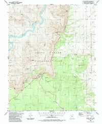
1988 Map of Desert View
USGS Topo · Published 1988About this map
The Palisades of the Desert form a striking geological boundary along the eastern edge of Grand Canyon National Park in this 1980s topographic study. The settlement at Desert View serves as a primary hub for visitors, featuring a prominent Observation Tower and several overlooks including Navajo Point and Lipan Point. The elevation drops dramatically from the rim down to the Colorado River, where the Tanner Rapids and Unkar Creek Rapids mark the turbulent passage through the canyon floor.
Find a feature on this map
38 named features on this map. Tap any name to fly to it.
Don’t see what you’re looking for? This feature index may not catch every label — zoom into the map to look around manually.
Map Details
Editions of this 1988 Desert View Map
2 editions found
Other maps of this area

1886 · San Francisco Mtns
USGS Topo · 1:250,000

1886 · Echo Cliffs
USGS Topo · 1:250,000

1891 · San Francisco Mtns
USGS Topo · 1:250,000

1891 · Echo Cliffs
USGS Topo · 1:250,000

1894 · San Francisco Mtns
USGS Topo · 1:250,000

1899 · San Francisco Mtns
USGS Topo · 1:250,000

1907 · Vishnu
USGS Topo · 1:48,000

1947 · Flagstaff
USGS Topo · 1:250,000

1954 · Flagstaff
USGS Topo · 1:250,000

1955 · Blue Spring
USGS Topo · 1:62,500