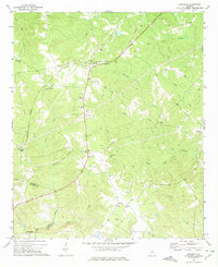
1972 Map of Devereux
USGS Topo · Published 1975About this map
Devereux serves as a central hub in this agricultural region of Hancock and Baldwin counties, situated where the Georgia railroad line meets the rolling drainage of Fort Creek and Zoie Creek. The landscape is a network of small settlements and family-named landmarks, such as Moate and Zebulon, connected by rural routes like Georgia 22. This 1970s survey illustrates a landscape deeply tied to its local institutions, featuring numerous rural houses of worship including Stancil Grove Ch and Sandy Run Ch.
Find a feature on this map
48 named features on this map. Tap any name to fly to it.
Don’t see what you’re looking for? This feature index may not catch every label — zoom into the map to look around manually.
Map Details
Editions of this 1972 Devereux Map
This is the sole edition of this map. No revisions or reprints were ever made.
Other maps of this area

1912 · Milledgeville
USGS Topo · 1:62,500

1953 · Athens
USGS Topo · 1:250,000

1958 · Athens
USGS Topo · 1:250,000

1959 · Athens
USGS Topo · 1:250,000

1961 · Deepstep
USGS Topo · 1:24,000

1961 · Warthen NW
USGS Topo · 1:24,000

1963 · Athens
USGS Topo · 1:250,000

1972 · Shoulderbone
USGS Topo · 1:24,000
1972 · Lake Sinclair East
USGS Topo · 1:24,000
1972 · Sparta
USGS Topo · 1:24,000