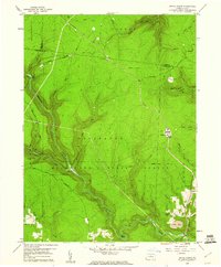
1959 Map of Devils Elbow
USGS Topo · Published 1960About this map
Moshannon State Forest dominates this mid-century landscape at the intersection of Clearfield, Cameron, and Elk Counties. The remote nature of the terrain is evident in the network of unpaved access ways like Number Eleven Road and the Caledonia Trail, which weave through deep drainage drafts and high ridges. The presence of a Radio Range Station and a Lookout Tower underscore the area's strategic use for forestry management and early aviation navigation during this period.
Find a feature on this map
39 named features on this map. Tap any name to fly to it.
Don’t see what you’re looking for? This feature index may not catch every label — zoom into the map to look around manually.
Map Details
Editions of this 1959 Devils Elbow Map
4 editions found
Other maps of this area

1929 · Karthaus
USGS Topo · 1:62,500

1929 · Clearfield
USGS Topo · 1:48,000

1932 · Clearfield
USGS Topo · 1:62,500

1932 · Karthaus
USGS Topo · 1:62,500

1941 · Benezette
USGS Topo · 1:62,500

1943 · Benezette
USGS Topo · 1:62,500

1945 · Driftwood
USGS Topo · 1:48,000

1945 · Sinnemahoning
USGS Topo · 1:24,000

1945 · Driftwood
USGS Topo · 1:24,000

1947 · Sinnemahoning
USGS Topo · 1:24,000
Featured Places
- Karthaus Township, PA
- Benezette Township, PA
- Piper, Karthaus Township
- Girard Township, PA
- Covington Township, PA