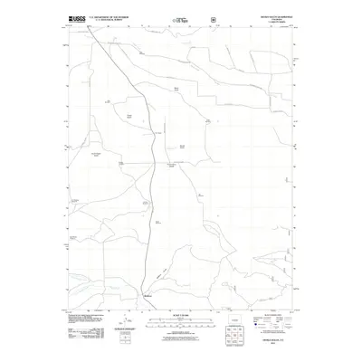
2011 Map of Devils Gulch
USGS Topo · Published 2011About this map
Bradford anchors the southern portion of this high-altitude landscape, where the confluence of North Muddy Creek and South Muddy Creek forms the main stem of Muddy Creek. The terrain is defined by a series of dramatic drainages including Devils Gulch, Watkins Gulch, and Moss Gulch, all separated by the prominent Promontory Divide. This area is characterized by a high concentration of water-pumping infrastructure, essential for ranching in this arid region, as evidenced by numerous named features such as the Hess Windmill, Oaks Windmill, and Jim Watkins Windmill. These landmarks, alongside the Akin Ranch, illustrate the persistent agricultural and pastoral patterns of Huerfano County in the early 21st century. The map also traces a network of rural routes like Centennial Ranch Rd and Electric Ave, which connect the isolated homesteads and grazing lands.
Find a feature on this map
35 named features on this map. Tap any name to fly to it.
Don’t see what you’re looking for? This feature index may not catch every label — zoom into the map to look around manually.
Map Details
Editions of this 2011 Devils Gulch Map
This is the sole edition of this map. No revisions or reprints were ever made.
Other maps of this area

1889 · Canon City
USGS Topo · 1:125,000

1889 · Huerfano Park
USGS Topo · 1:125,000

1892 · Huerfano Park
USGS Topo · 1:125,000

1892 · Canon City
USGS Topo · 1:125,000

1954 · Rosita
USGS Topo · 1:24,000

1954 · Trinidad
USGS Topo · 1:250,000

1954 · Pueblo
USGS Topo · 1:250,000

1955 · Trinidad
USGS Topo · 1:250,000

1957 · Pueblo
USGS Topo · 1:250,000

1957 · Aldrich Gulch
USGS Topo · 1:24,000