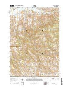
2014 Map of Devils Heel
USGS Topo · Published 2014About this map
Ironside Valley sits at the southern edge of this high-desert landscape where the border between Baker and Malheur counties cuts through the terrain. The northern reaches are defined by the Burnt River and the engineered paths of the McPherson Ditch and Eldorado Ditch, which trace the contours of the slopes to manage water in this arid environment. The landmark known as Devils Heel stands near the center of a complex network of seasonal drainages, including Chicken Cr and Fish Cr. Transportation is limited to a few arterial routes like the Dooley Mountain Hwy 245 and remote tracks such as McCoy Rd. The prominence of named ditches and gulches, like Rail Gulch, reflects the long-standing importance of water rights and ranching infrastructure in this corner of Eastern Oregon.
Find a feature on this map
36 named features on this map. Tap any name to fly to it.
Don’t see what you’re looking for? This feature index may not catch every label — zoom into the map to look around manually.
Map Details
Editions of this 2014 Devils Heel Map
This is the sole edition of this map. No revisions or reprints were ever made.
Other maps of this area

1901 · Baker City
USGS Topo · 1:125,000

1901 · Sumpter
USGS Topo · 1:125,000

1908 · Ironside Mountain
USGS Topo · 1:125,000

1955 · Baker
USGS Topo · 1:250,000

1955 · Canyon City
USGS Topo · 1:250,000

1959 · Baker
USGS Topo · 1:250,000

1959 · Canyon City
USGS Topo · 1:250,000

1964 · Ironside
USGS Topo · 1:62,500

1967 · Dooley Mtn
USGS Topo · 1:24,000
1967 · Brannan Gulch
USGS Topo · 1:24,000