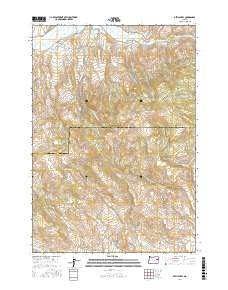
2017 Map of Devils Heel
USGS Topo · Published 2017About this map
Burnt River flows through the northern reaches of this high-elevation terrain, marking a landscape defined by its complex watershed and historic water management. The presence of the Eldorado Ditch and McPherson Ditch illustrates the early engineering efforts required to divert water across this arid high-country divide. Straddling the boundary between Baker and Malheur counties, the map centers on the prominent Devils Heel landform and the upper reaches of Ironside Valley. A dense network of seasonal and perennial drainages, including Mill-Boulder Cr and Milk Ranch Boulder Cr, dissect the slopes, while primitive routes like Pine Creek Rd and McCoy Rd provide the only access into these remote basins and gulches.
Find a feature on this map
34 named features on this map. Tap any name to fly to it.
Don’t see what you’re looking for? This feature index may not catch every label — zoom into the map to look around manually.
Map Details
Editions of this 2017 Devils Heel Map
This is the sole edition of this map. No revisions or reprints were ever made.
Other maps of this area

1901 · Baker City
USGS Topo · 1:125,000

1901 · Sumpter
USGS Topo · 1:125,000

1908 · Ironside Mountain
USGS Topo · 1:125,000

1955 · Baker
USGS Topo · 1:250,000

1955 · Canyon City
USGS Topo · 1:250,000

1959 · Baker
USGS Topo · 1:250,000

1959 · Canyon City
USGS Topo · 1:250,000

1964 · Ironside
USGS Topo · 1:62,500

1967 · Dooley Mtn
USGS Topo · 1:24,000
1967 · Brannan Gulch
USGS Topo · 1:24,000