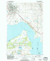
1994 Map of Devils Lake
USGS Topo · Published 1995About this map
Devils Lake serves as the focal point for this mid-1990s survey, illustrating the complex geography where the city meets the water's edge. The map highlights a significant institutional presence in the community, featuring the State School for Deaf, St Josephs Sch, and Minnie H Sch alongside the Mercy Hosp complex. These public and private anchors are situated near the historic Devils Lake Cem and the G A R Cem, providing essential details for those researching the town's social and genealogical history. To the south, the landscape transitions into the Fort Totten Indian Reservation boundary, where the Shelvers Grove State Rec Area and the National Waterfowl Production Area indicate a shift toward conservation and recreation. An Old Railroad Grade cutting across the terrain offers a tangible trace of former transportation routes that once linked these northern prairie settlements.
Find a feature on this map
39 named features on this map. Tap any name to fly to it.
Don’t see what you’re looking for? This feature index may not catch every label — zoom into the map to look around manually.
Map Details
Editions of this 1994 Devils Lake Map
This is the sole edition of this map. No revisions or reprints were ever made.
Other maps of this area

1928 · Tokio
USGS Topo · 1:62,500

1930 · Hamar
USGS Topo · 1:62,500

1931 · Tokio
USGS Topo · 1:62,500

1931 · Devils Lake
USGS Topo · 1:62,500

1950 · Tokio
USGS Topo · 1:24,000

1950 · Devils Lake
USGS Topo · 1:62,500

1951 · Crary
USGS Topo · 1:24,000

1951 · Devils Lake
USGS Topo · 1:24,000

1951 · Grand Harbor
USGS Topo · 1:24,000

1951 · Camp Grafton
USGS Topo · 1:24,000